MENU

The two mission churches of Ysleta and Socorro and the presidio chapel of San Elizario, located along the El Paso Mission Trail, stand as enduring symbols of the long and rich history of their respective communities, as well as the nations of Spain, Mexico and the United States. All three are privately owned by the Catholic Diocese and are actively supported by their local parishes. These landmarks and their environs are listed in the National Register Historic Places.
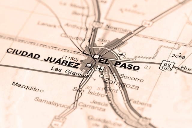
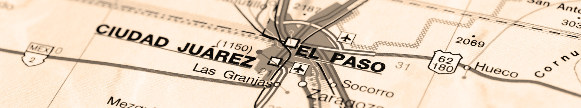
Socorro Road (FM 258), which runs from Ysleta to Socorro to San Elizario, is the designated Mission Trail. This nine-mile route represents a segment of El Camino Real de Tierra Adentro (Royal Road of the Interior), the historic trail that extended from Mexico City to Santa Fe, and linked the missions,-agricultural communites, haciendas(landed estates) and presidios (military forts) to distant trade and supply routes. It is thr oldest and once the longest road in North America, and was designated as a National Historic Trail in 2000.
When the Spanish explorers arrived in this new world, the semi-namadic Mansos and Sumas occupied the El Paso area. The Mansos, many of whom lived along the Rio Grande, earned their Spanish, manso means "quiet" or "tame". These people hunted, gathered and practiced horticulture. For thousands of years, indigenous peoples encountered each other as they traveled and traded the many trails that later became El Camino Real de Tierra Adentro.
The Spanish colonial government chose Don Juan de Oñate, a wealthy nobleman from Zacatecas, to organize an expedition to settle the lands north of New Spain (Mexico) and establish a "New" Mexico. The expedition departed Santa Barbara, Chihuahua, in January 1598. The 500 colonists included soldiers, their wives, children, Franciscan clergy, Indians and servants.
More than eighty carts and wagons and thousands of head of livestock formed a caravan almost two miles long. The caravan traveled a northerly route for weeks across the Chihuahuan Desert, until it reached the banks of the Rio Grande in the vicinity of present-day San Elizario on April 30, 1598, Onate called for a rest and celebration. The Spanish were joined by local Manso Indians. Together they held a Mass and enjoyed a Thanksgiving feast. This celebration took place in an area that today the United States, twenty-three years before the Pilgrims feast at Plymouth, Massachusetts. Oñate performed the ceremony of La Toma (Taking Possession), in which he claimed the new province for King Phillip ll.
The colonists trekked upstream and crossed the Rio Grande near today's La Hacienda Café on May 4, 1598. They named that ford El Paso del Río del Norte (The Pass Accross the River of the North). The caravan continued north to found permanent settlements in northern New Mexico, extending the Camino Real from Mexico City to Santa Fe - a distance of more than 1,500 miles.
In 1659, Fray García de San Francisco arrived at the Pass of the North to convert the local Manso and Suma lndians. On December 8, 1659, he held a Mass in this newly erected adobe struture that was dedicated Nuestra Señora de Guadalupe del Paso (Our Lady of Guadalupe at the Pass). In 1662, with the help of the Indians, Fray García began building a larger mission on a rocky plateau west of the river. The community of El Paso del Norte grew up around the church, which still stands on the Plaza in downtown Ciudad Juárez. It remains the oldest structure in the El Paso area.
In 1680, the biggest Indian revolt in the history of the Americas took place in northern New Mexico. Pueblo tribes united to overthrow the Spanish colonial rulers. Almost 2,000 Spaniards and hundreds of Tigua and Piro Indians fled south on El Camino Real to the safety of El Paso del Norte. As a result, new communities were established on the south side of the river for the re-settlement of the refugees - San Lorenzo, Senecú del Sur, Ysleta del Sur and Socorro del Sur.
The refugees from New Mexico established El Paso del Norte as their headquarters and prepared for the reconquest of northern New Mexico, which eventually occurred in 1692.
The Rio Grande encountered by the early Spanish explorers in the El Paso del Norte region was very different than it is todav. Meandering over a wide flood plain, the river teemed with more than twenty species of native fish. Thr cottonwood bosque (woods), meadows and wetlands that lined the river were alive with a wide variety of birds and animals, including the majestic jaguar. Most years, snowmelt in the upper basin brought spring floods; this flooding provided fertile soil for the planting of corn, wheat, grapes, apricots and other crops. 'The Rio Grande is considered to be a provider of life, and is central to many of the Tigua Indians religious ceremonies and customs.
The river presented great challenges to the settlers of the El Paso del Norte region.The Massive floods of 1740 and 1829 greatly damaged the missions at Ysleta and Socorro, and the flood of 1829 also destroyed the chapel at San Elizario.
The turbulent Rio Grande also played a role in the shifting geopolitical boundaries of the borderlands. Prior to 1829, the churches st Ysleta, Socorro and San Elizario were located on the south bank of the river.
After the floodwaters of 1829 had subsided, the Rio Grande had ,cut a new channel to the southwest, placing Ysleta, Socoro and San Elizario on the northern bank of the river. Following the U.S.-Mexico War (1846-1848), the deepest channel of the Rio Grande was declared by the United States as the international boundary, thereby permanently placing these three comunities in the Republic of Texas.
The construction of Elephant Butte Dam in 1916 put an end to the annual floods that devastated the val ley. During the 1930s, thc river was straightened for flood protection, and cottonwoods were cut clown. Today, the river serves as an irrigation waterway for El and the surrounding valley farms.
At the El Paso city limits, and adjacent to the Mission Trail, is the 372-acre Rio Bosque Wetlands Park. The park consist of trails and restored habitats, riverside woods and native ecosystems once found in abundance in the river valley. Managed by the University of Texas at El Paso, the park is open to the public.
Ysleta Mission is thr oldest continuously active parish in the state of Texas, and the community of Ysleta is the oldest town in Texas. The town was one of several agricultural communities started along the Rio Grandc by Spaniards and Indians after the 1680 Pueblo Revolt. The Tigua Indians, who were forced to flee their pueblo at Isleta, New Mexico, have since occupied the area continuously.
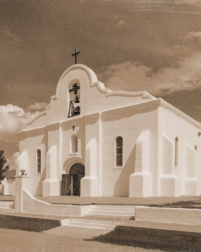
 On October 12, l660, the first Mass was held in Ysleta, and a temporary mission church wac built. In attendance were New Mcxico Governor Don Antonio de Otermín, 150 soldiers, Spanish colonists and 317 Indians, including more than 100 Tiguas. In 1692, the Tiguas founded Ysleta del Sur Pueblo,and by 1692, the tribe built a larger mission, Corpus Cristi de los Tiguas de Ysleta. The Spanish term, del sur (of the south) differentiates the southern pueblo from the northern mother pueblo of Isleta, New Mexico. The church was also called the San Antonio Mission after the patron saint of thr Tiguas, This building, dedicated to Our Lady of Mount Carmel lasted until the disastrous flood of 1740, and was rebuilt in 1744 on what was then established farmland. 1744 mission was later washed away bv the flood of 1829. In late 1851 the present Ysleta mission was completed and reopened for services. The mission appeared as a simple, rectangular stack of blocks. The facade was later changed to a pitched, gable shape. About 1897, the gable was enlarged and a beehive-shaped dome bell tower was added.
In 1907, most of the church was destroyed by fire. Only the sacristy remained unscathed. The church was rebuilt using the original sacristy and the remaining adobe walls. The gabled facade was stepped upward with Mission Revival detailing, limited fenestrations and unadorned surfaces, culminating with a high, central arch. The massive bell tower was also altered, adding the familiar silver dome, capping three centuries of natural disasters.
The Tiguas are still loyal to their patron saint, San Antonio de Padua, whose name they identify with the mission. The Tigua feast day of San Antonio is observed on June 13, with a morning mass followed by traditonal dances. Our Lady of Mount Carmel feast day is celebrated around the 16th of July with a festive bazaar.
The Tiguas, who helped the United States military as scouts during the 19th century Indian wars, were finally recognized as a tribe by the state of Texas in 1967 and by the United States Congress in 1968.
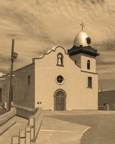
Socorro (help), took its name from Socorro, New Mexico, from which the Piro Indians fled following the Pueblo Revolt of 1680. Records show that Socorro was officially founded during a Mass delivered by Fray Anonio Guerra on October 13, 1680.
 Socorro's first permanent mission was in use bv circa 1691. At that time, Socorro was comprised of sixty Piro Indian families and fifteen Spanish families. The mission was built by the Piros under the direction of Franciscan missionaries and dedicated as Nuestra Señora de limpía Conception de los Piros de Socorro del Sur. (Our Lady of the Immaculate Conception of the Piros of Socorro of the South).
Many of the parishoners refer to their mission as San Miguel (St. Michael), in honor of their patron saint; or as La Purísima, in honor of the Blessed Virgin, Forever Pure. When the 1740 flood destroyed the original structure, the parishioners replaced it nearby. That second structure was also lost to flooding in 1829. Rebuilding was completed in 1843.
Archaeological evidence suggests that decorative, carved cottonwood and cypress roof supports called vigas (beams) and decorative corbels supporting the vigas were salvaged from Socorro's, first mission, dating to circa 1691. Oral histories relate that the Piro people painted the designs on thc vigas and corbels using plant-based pigments. The walls were constructed of adobe and finished with plaster. The front stepped facade with its center-placed bell tower has been compared to the decorative design motifs associated with many Pueblo Indian tribes. the building represents the best elements of Indian and Spanish design still preserved in El Paso County.
Other significant features of the Socorro Mission include theadjacent rectory, dating to the 1840s period of mission construction; the camposanto (cemetery) featues four unique small descansos (structures) that serve as resting areas. The large open area in front of the mission recalls the former plaza, and adjoining portions of the acequias (irrigation system) also remain.
The mission was completely restored through a ten-year, community-based collaboration and reopened for use with a Mass on December 7, 2005.
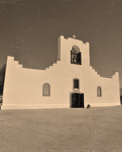
Spain sought to protect its interests in the northern frontier by establishing a network of presidios (military forts). A presidio was built in 1684 in El Paso del Norte. In 1789, a presidio named after San Elcear (San Elceario), the French patron saint of soldiers, was established at the site of the Hacienda de los Tiburcios, located some thirty miles downriver from El Paso del Norte. The settlement that grew up around the presidio became known as San Elizario (a corrupted version of San Elcear). The presidio included a post chapel that served the soldiers and their families.
The flood of 1829 destroyed the original chapel, which was rebuilt in the same vicinity. When Mexico won its independence from Spain in 1821, the importance of the presidio diminished. San Elizario gradually became a prosperous farming community and became the first seat of El Paso County government in 1850.
The present-day chapel was completed in 1882. Since then, the exterior of the building has changed little, except for the front facade. The interior was damaged by fire in 1935 and has experienced dramatic changes. A pressed-tin ceiling covers the original ceiling beams, and the plain wood columns have been boxed in by decorative posts.
The San Elizario Chapel reflects the influence of European architectural styles on the earlier, box-like missions of the region. this large, elevated adobe structure anchors the plaza, and its imposing presence exemplifies the influence of the chapel on the surrounding community.
Features of the surrounding landscape, such as the orchard to the east of the chapel, the plaza, and a substantial stock of adobe buildings that comprise the San Elizario Historic District, provide a setting compatible with the 19th century establishment of the present chapel. The formal rectangular grid pattern of streets, plaza and building orientation continues to reflect the elements of Spanish colonial town planning.
**This tourist guide was a collaborative effort among the Mission Trail Association, El Paso CVB, The El Paso Community Foundation and the El Paso County Historical Commission. A hardcopy version can be picked up at any El Paso Visitors Information Centers.